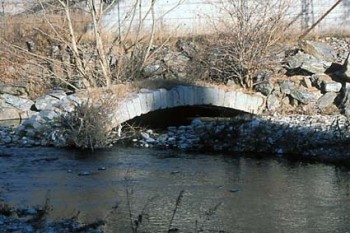
 Salendo dalla Strada Statale verso Edolo, all’altezza del ponte moderno che supera il fiume Oglio, sotto la rupe dominata dalla chiesetta di S. Andrea, sulla destra, accanto al letto del fiume, si trovano i resti di un vecchio ponte in muratura. Se, superato il ponte moderno si parcheggia e ci si inoltra a piedi verso l’Oglio come per ritornare verso la bassa valle, scrutando in direzione della statale, si può vedere un’arcata realizzata in pietre squadrate legate con malta, parzialmente coperta dalla vegetazione e in parte immersa nel fiume. La struttura, venuta alla luce a seguito della grande alluvione che nel 1960 interessò la valle, viene attribuita ad un ponte ascrivibile all’età romana. Si tratterebbe di uno dei pochissimi resti finora rintracciati della strada romana che da Brescia attraversava la Valcamonica fino a raggiungere il Passo del Tonale da un lato e quello dell’Aprica dall’altro. L’abitato di Sonico (forse in antico Summus Vicus) era uno dei tanti centri minori che costellavano la valle romana.
Going from the main road to Edolo, at the modern bridge that crosses the river Oglio, below the cliff is dominated by the church of S. Andrea, on the right, next to the bed of the river, are the remains of an old stone bridge. If passed the the bridge and you park and you proceed on foot to the river Oglio like to return to the lower valley, looking towards the main road, you can see an arch made of square stones bound with mortar, partially covered by vegetation and partly submerged in the River. The property came to light after the great flood in 1960 that interested in the valley, is attributed to a bridge due to Roman times. This would be one of the few remains so far traced the Roman road that ran through Camonica Valley from Brescia town up to the Tonale Mountain Pass one hand, and Aprica mountain Pass on the other hand. The town of Sonico (perhaps in ancient Summus Vicus) was one of many small towns that lined the Roman valley.
Le altre architetture civili:
–> Torre DePari


